Title

Text if Needed
 

Confirm Trip Deletion

Are you sure you want to delete this trip?

Delete Cancel
User mode: Stranger/Member
Logged In: Not Logged In/Logged In
Trips:
Working trip index: 1
Trip edited: No
Trip has saves: No

Edit my Account info

Optional instructional text here

Create an Account

Some text here

Import Trip Plans - Decommissioned

You or someone using this computer or device previously created Trip Plans.
What should we do with these plans?
Make these Trip Plans part of my account
Discard these Trip Plans

Login

Some text here

Password Reset

Please enter the email you used to set up your account.
We'll send a link to use to reset your password.

Check Your Email

If there is an account with the email address , we will send you a link to reset your password

Create a Trip

Save your favorites to your own customizable trip

Check Your Email

We've sent a link to let you reset your password

Favorites

You currently have no favorites saved.

Save
  • Trip Template
See all of my trips
Create a New Trip
Sign In or Join to preserve your plans:
All Trips
  • Trip Template
 
 
Start Date:  

Day Planner

Drag saved items onto the calendar to plan your trip day by day
Trip Length:   

Adventures

Upcoming Trips

Add New Adventure
Make Active
Trip title
  • days
  • favorites
  • scheduled
  • Edit
  • Day Planner
  • View Favorites
  • Delete

Past Trips

Trip title
  • days
  • favorites
  • scheduled
  • Edit
  • Day Planner
  • View Favorites
  • Delete
Placeholder
Alert here
 
 
  • 36°
  • Heber Valley, Utah
  • Saturday, April 20, 2024
  • 07:46 AM
Mostly Cloudy 36°
Sunday H: 64°
L: 32°
Partly Sunny
Monday H: 72°
L: 40°
Partly Sunny
Tuesday H: 71°
L: 39°
Mostly Cloudy
Wednesday H: 73°
L: 40°
Partly Cloudy
Thursday H: 69°
L: 36°
Partly Sunny

Upper Big Hollow Trail

Upper Big Hollow Trail

DIRECTIONS: Take Hwy 189 to 3000 S in Daniels, turn west and go 1 mile to Big Hollow Road, turn right and follow signs to Big Hollow Gun range. When you reach the range, turn left into the dirt road with the sign reading "Wallsburg Wildlife Management Area". Follow this road for 2 miles until you see parking on your right. Trail starts straight west from parking lot.

DIFFICULTY: Moderate (sections of steep climbing)

LENGTH: Up to a 5 mile loop

AVERAGE HIKE TIME:The loop would be difficult for young kids, an in-and-out for an hour or so still offers great views

TRAIL USERS: Hikers, bikers, horses, and dogs

BEST TIME OF YEAR TO HIKE: Gate closes for the winter/early spring, best to go in summer/fall

COST: free

TRAIL CONDITIONS: Single track, rocky in places, the last half of the loop is on a gravel road

SUN EXPOSURE: A few trees provide shade but expect to be in full sun the majority of the hike

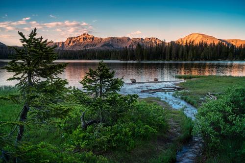
WATER: No drinking fountains, but during some parts of the year a small stream could be flowing (for your dog to get a drink, or for water filtration if you so desire)

RESTROOM: No

WATCH FOR: GUNS EL GUAPO! The Big Hollow shooting range is near-by and the lower trailhead is often used for a shooting range (in fact, this whole "wildlife management area" seems to be the local's shooting range). Wear bright colors, make lots of noise, and don't hike here if you feel nervous (i.e. if you find shooting targets along the trail or someone is shooting when you arrive). The trail goes the opposite direction of any shooting we've encountered, and the view is worth it, we promise.


Customizable Directions

trip
To start planning your next : Drag and drop items here Or click the icon
trip
Start time:
Duration:

Loading...

Opening in a new tab...